
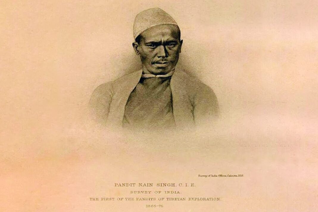

Born in a remote Himalayan village, Pandit Nain Singh Rawat became one of the most remarkable explorers and surveyors of the 19th century. Traveling through some of Tibet’s most inaccessible regions, often in disguise and under extraordinary conditions, he helped map territories largely unknown to the outside world.
Nain Singh Rawat was born in 1830 in Milam, one of the last villages of the Johar Valley in present-day Pithoragarh district of Uttarakhand. The valley was home to the Shauka community, whose semi-nomadic traders and pastoralists had maintained commercial links with Tibet for generations.
Growing up in this environment gave Nain Singh an unusual advantage. From a young age, he accompanied elders of his family on trading journeys across the Himalayas. Long before he received any formal training in surveying, he had already developed an intimate understanding of mountain routes, weather, terrain, and survival at high altitudes.
A major turning point came in the 1850s, when European geographers were attempting to gather reliable geographical information about Tibet. German explorers Adolf and Robert Schlagintweit came to India to conduct scientific research with the assistance of the Survey of India. Their work eventually brought them into contact with Nain Singh and his cousins Kishan Singh and Man Singh.
Their knowledge of the Himalayan terrain made them invaluable. Nain Singh became associated with one of the earliest scientific efforts to study and map the difficult Himalayan region systematically.
After this assignment, he returned to Milam and served as the headmaster of a vernacular school until 1863. But his life was soon to change again.
Impressed by his earlier work, officials of the Great Trigonometrical Survey summoned Nain Singh and his cousin to Dehradun for specialized training. Over nearly two years, they were taught to use surveying instruments, make astronomical observations, calculate altitude, and record geographical information while traveling through unfamiliar territory.
Nain Singh proved to be an exceptionally quick learner. His years as a shepherd and traveler had already made him familiar with major stars, constellations, and their movements across the night sky.
One of the most ingenious techniques he learned involved an object that would attract little suspicion: a Buddhist prayer rosary.
A traditional rosary used by Tibetan lamas contained 108 beads. For the surveyors, a specially designed rosary containing 100 beads was prepared. As Nain Singh walked, he counted his steps. After every 100 paces, he moved his fingers to the next bead. Completing the entire rosary represented 10,000 steps.
By maintaining a carefully calibrated stride, he could estimate distances remarkably accurately without carrying equipment that might reveal his true purpose. Scientific observations could therefore be concealed within the ordinary appearance of a traveler or pilgrim.
Following their training, Nain Singh and his companions entered Tibet, sometimes disguising themselves as traders and at other times as religious travelers.
His landmark expedition came in 1865–66, when he traveled approximately 1,200 kilometers from Kathmandu to Lhasa before returning to India through the region of Lake Manasarovar. The journey marked the beginning of a series of extraordinary expeditions that would establish his reputation as one of India’s greatest explorers.
Traveling across Tibet at the time was both physically dangerous and politically sensitive. Foreign access was severely restricted, making open geographical surveying virtually impossible. Nain Singh therefore had to observe, calculate and record information without attracting attention.
Over roughly the next decade and a half, his expeditions took him across vast stretches of the Himalayas and the Tibetan plateau. His geographical work covered regions extending from the sources of major rivers such as the Sutlej and Indus to Ladakh and other parts of the Himalayan frontier. His journeys also brought him through areas associated with Assam, Bengal and Bhutan.
The risks were considerable. During one expedition, he was reportedly imprisoned for 18 days. Yet he continued his work.
Among his greatest achievements was providing some of the earliest reliable scientific geographical information about Lhasa and the Manasarovar region. He measured Lhasa’s altitude above sea level and helped determine its latitude and longitude with remarkable accuracy. His observations significantly improved contemporary knowledge of Tibet’s geography.
His final major official expedition, undertaken in 1874–75, took him from Ladakh to Lhasa and onward towards Assam. During these journeys, he crossed extraordinarily remote regions that were almost entirely unknown to geographical science at the time.
International recognition followed.
In 1877, the Royal Geographical Society honored Nain Singh Rawat with its prestigious gold medal for his exceptional journeys and surveys in Tibet and the upper Brahmaputra region. His work was particularly celebrated for helping establish the geographical position of Lhasa and significantly expanding knowledge of the geography and cartography of Asia.
The Geographical Society of Paris also recognized his achievements. His extraordinary knowledge and experience eventually earned him the honorific by which he became famous- “Pandit” Nain Singh Rawat.
He died on February 1, 1895, leaving behind a legacy far larger than the isolated Himalayan village where his journey had begun.
Today, Milam is largely deserted, but the story of its most famous son still holds an important place in the history of exploration.
Nain Singh Rawat worked without satellites, GPS, or modern communication systems. Armed instead with astronomical observations, scientific instruments, carefully counted footsteps and an extraordinary understanding of the mountains, he helped transform unknown stretches of the Himalayas and Tibet into measurable geography.
From a young trader walking ancient Himalayan routes to an internationally honored explorer mapping one of the world’s most inaccessible regions, Pandit Nain Singh Rawat’s life remains a remarkable chapter in the history of Indian geographical exploration.
Also Read: From Guns to Glamour: Surrendered Naxal Women Walk Fashion Ramp
You can connect with DNN24 on Facebook, Twitter, and Instagram and subscribe to our YouTube channel.